


 Listen Live

HARRISONBURG VA: (Rocktown Now) – On Friday, September 6th 1996, the National Weather Service issued a statement that read. …NEAR RECORD FLOODING EXPECTED…and advised “RIVERS ARE EXPECTED TO REACH LEVELS SIMILAR TO THOSE SEEN DURING THE JANUARY 1996 FLOOD…CRESTS COULD BE NEAR RECORD LEVELS.” What followed was flooding that caused rivers to rise to over 35 feet, flooded buildings, washed out roads and was responsible for seven fatalities across Virginia and West Virginia. The National Weather Service is Sterling looked back on the flood in this release.
From the National Weather Service
Some mid-Atlantic residents consider 1996 to be the “year of the floods.” It’s a title that is well-deserved. A significant snowmelt contributed to a major flood in January 1996. Later, in June, a significant storm dropped nine inches of rain in three hours in the Monocacy River basin near Gettysburg, causing major flooding in that historic Pennsylvania town and one of the most significant floods on the Monocacy on record. The area just missed the worst impacts of the remnants of Hurricane Bertha in July.
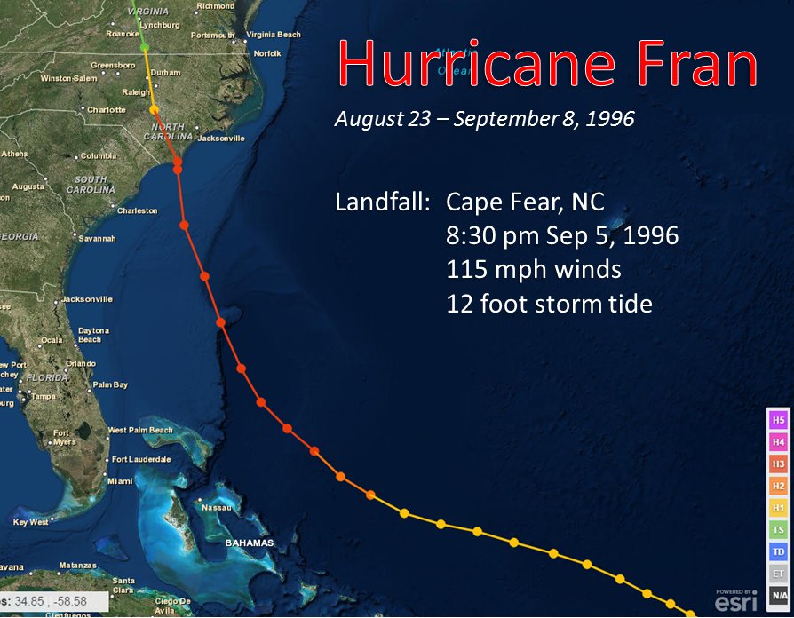
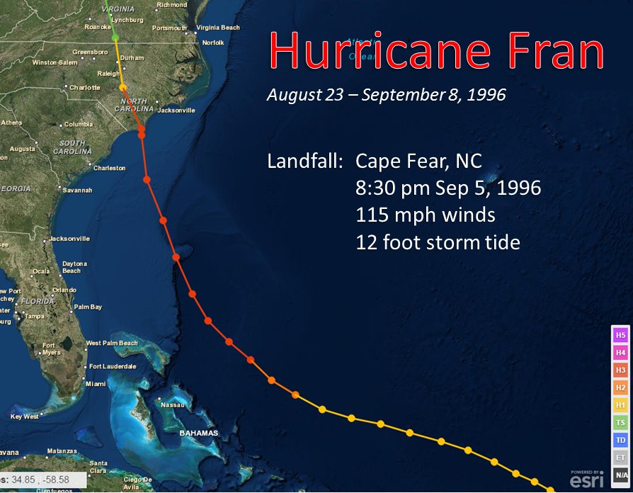
Then came late August and September. A tropical wave came off the African coast, quickly developing into a tropical depression on August 23rd. The depression strengthened into Tropical Storm Fran on August 27th, and continued to strengthen, becoming a hurricane the very next day. The storm tracked north of the Lesser Antilles and the Bahamas, still strengthening in the warm Atlantic waters. By September 4th, Fran was a powerful Category 3 hurricane with 120 mph sustained winds. The storm made landfall in southeastern North Carolina, near Cape Fear, the following day, moving inland and weakening, but still carrying plentiful tropical moisture northward with it.
This review will recap the impacts of Fran in the Baltimore/Washington service area.
Heavy Rain
While Fran was the main contributor to the flooding and its severity, rain had been falling for a couple days before Fran was even a factor. The circulation around Hurricane Edouard, which had been a near-miss to New England, combined with an upper-level disturbance parked over the mid-South, brought deep moisture into the region as early as September 4th, with widespread rainfall totals of 1 to 2 inches having already occurred and increasing stream levels.
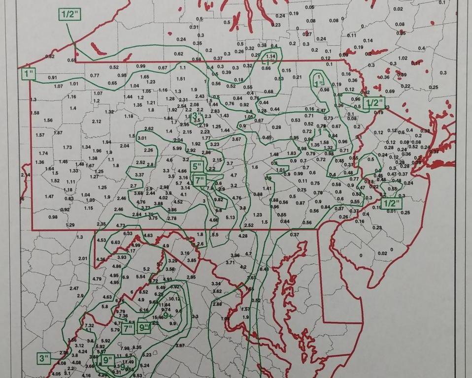
As Fran moved inland on the evening of September 5th into early September 6th, widespread heavy rainfall was occurring north of the storm center. In addition to the copious tropical moisture, the wind direction favored upslope precipitation on the east side of mountains, including the Blue Ridge. Widespread 6 to 10 inch amounts were observed, with over a foot in Nelson, Augusta, and Page Counties. 15.61 inches of rain fell at Big Meadows atop the Blue Ridge in just 24 hours. Upslope portions of Pendleton and Hardy Counties in West Virginia also tallied up to 14 inches of rain.
Predictability
A full 24 hours before flooding began in Virginia, the Sterling NWS office issued an updated flood watch with strongly worded information, stating:
“Even heavier rains are likely later tonight and Friday as the remnants of Hurricane Fran approach the region. This may result in catastrophic flooding in some locations . . . particularly over the Piedmont and mountains of West Virginia.”
Warnings for the Potomac River were very timely, providing more than 12 hours lead time before flood stage was reached, and between 38 and 50 hours lead time prior to the peak level. This afforded people in Point of Rocks enough time to rent trucks and trailers to move belongings from the flood plain before flooding occurred.
The Harrisonburg Daily News Record wrote in an editorial after the storm:
“Meteorology and weather forecasting involve a critical blend of science and luck, and through divine graces, the region received the benefits of some pretty good science. Schools closed Friday before the worst of the storm was forecast so buses did not have to hazard across washed out roads. Many offices were never opened or closed early on Friday, providing employees the chance to stay home or make their way home before roads began closing.”
Fatalities
There were seven fatalities within what is today’s NWS Baltimore/Washington service area:
2 – Montgomery County – swept away in car
2 – Augusta County – swept away while trying to cross a bridge
1 – Highland County – drowned when crossing flooded area
1 – Pendleton County – drowned when drove car into flood waters
1 – Grant County – drowned when drove tractor into flood waters
Local Flood Reports
As Fran made landfall on the Carolina coast, Jim DeCarufel of the Sterling NWS office told the Washington Post, “We’ve had no flooding yet, but there by gosh will be.” And there certainly was.
Flash flooding was a big story in Virginia, West Virginia, and Maryland. In Harriston (Augusta County), Paines Creek escaped its banks, flooding more than a dozen trailer homes and spilling kerosene into the water. A resident of Rockingham County who suffered damage to her home was unable to return for weeks as the water was insufferably slow to recede due to the high water table. Many of those who experienced damage did not have flood insurance and were not in the floodplain. In Shenandoah County alone, dozens of homes were damaged or destroyed and numerous roads were flooded. Southbound I-81 had to be closed just south of the Shenandoah Caverns exit – the first time that had ever been necessary.
Madison County, which had just been completely devastated by flash flooding in June 1995, was hit hard again – though this time moreso to infrastructure than personal tragedy. Dozens of privately-owned bridges were damaged or destroyed by raging floodwaters.
Elkton’s The Valley Banner writer Louis Andrews described flooding in Page County as follows:
“Ten days after the flood waters had receded, Naked Creek Road in Page County still appeared as if a wave of B-52 bombers had loosed their devastating payload on the tiny valley.
“What had been peaceful countryside before the Naked Creek became a rushing torrent has become a surrealistic landscape littered with a hodgepodge of gnarled roots, tree stumps, rocks, Styrofoam cups, splintered lumber, twisted metal, and the odd hubcap or old tire.”
Parts of Skyline Drive were washed away by floodwaters. A home adjacent to Luray High School was washed off its foundation – and onto the football field at the high school – by nine foot deep flood waters. Georges Creek, in far western Maryland, surged over its banks, causing significant damage to the towns of Moscow, Midland, Lonaconing, and Westernport.
River Flooding
With the rain over, river flooding then became the story.
A flood statement issued by the Sterling NWS office at 521 PM on Friday, September 6th was headlined:
…NEAR RECORD FLOODING EXPECTED…
and advised “RIVERS ARE EXPECTED TO REACH LEVELS SIMILAR TO THOSE SEEN DURING THE JANUARY 1996 FLOOD…CRESTS COULD BE NEAR RECORD LEVELS.”
The stream gauges at Cootes Store and Strasburg were damaged by the floodwaters, which did reach record levels at those locations.
Water actually reached Route 55 east of Strasburg at the North Fork Shenandoah – an incredible feat given how high the road is above the river. The bridge there had just been built higher in 1992 and yet still floodwaters reached it. Strasburg’s water treatment plant was inundated, requiring water conservation and a switch in sources for the town’s water.
There were multiple stories – both from public and private sources – of recovery efforts from the January flood having just been completed when the September flood struck. This included repairs in Harpers Ferry, the C&O Canal, and private residences.
The levee project in Petersburg and Moorefield, West Virginia was only about 45 percent complete when the flood struck, forcing a setback in the building process, but the contractor pushed dirt up before the storm to create a barrier that saved Moorefield from taking on three more feet of water than it did.
Harpers Ferry National Historical Park reported water in the first floor of 20 of their buildings, including all the ones that front Shenandoah Street. But the historical artifacts inside those buildings had been moved to higher ground.
The flood crest did not make it all the way down the Potomac until Sunday night (September 8th).
North Fork Shenandoah
Mount Jackson
21.50 feet
North Fork Shenandoah
Cootes Store
28.00 feet
North Fork Shenandoah
Strasburg
32.27 feet
South Fork Shenandoah
Lynnwood
30.80 feet
South Fork Shenandoah
Luray
33.30 feet
South Fork Shenandoah
Front Royal
32.57 feet
1.25%
Middle River
Grottoes
35.20 feet
< 1%
Shenandoah
Millville
26.82 feet
South Branch Potomac
Franklin
7 feet
19.16
16.06
22.58 (1985)
South Branch Potomac
Petersburg
12 feet
22.20
20.00
22.83 (1949)
South Branch Potomac
Springfield
15 feet
34.98
28.41
44.22 (1985)
Potomac
Harpers Ferry
18 feet
29.80
29.40
36.50 (1936)
South River
Waynesboro
9.5 feet
13.46
13.58
15.30 (1985)
South Fork Shenandoah
Lynnwood
None
30.84
24.88
30.84
South Fork Shenandoah
Front Royal
12 feet
32.57
25.20
34.80 (1942)
North Fork Shenandoah
Cootes Store
15 feet
27.86
19.71
27.86
North Fork Shenandoah
Strasburg
17 feet
32.27
27.96
32.27
Shenandoah
Millville
13.5 feet
26.84
23.61
32.40 (1942)