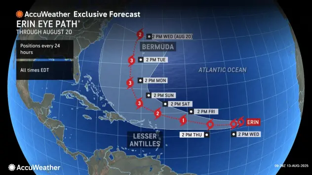
HARRISONBURG VA: (ROCKTOWN NOW) – Tropical Storm Erin is currently gaining strength in the Atlantic and is expected to become the first hurricane of the 2025 season later this week. As of this morning, Erin is producing sustained winds of around 45 mph and moving west at 22 mph. Forecast models suggest it will gradually turn toward the west-northwest and intensify into a hurricane by Thursday evening, potentially reaching Category 3 status by Sunday morning. While the storm’s exact path remains uncertain, recent model shifts have brought it slightly southward, increasing the possibility of a U.S. landfall somewhere between North Carolina’s Outer Banks and Bermuda. Even if Erin stays offshore, dangerous rip currents, high surf, and rough seas are likely along the East Coast. The northern Leeward Islands, Virgin Islands, and Puerto Rico may see 1–2 inches of rain as Erin passes nearby. Residents in the Greater Antilles, Bahamas, and along the U.S. East Coast should monitor updates closely and begin reviewing hurricane preparedness plans, especially with the peak of the season approaching in mid-September.
Caribbean, Bahamas on alert as Erin set to strengthen into hurricane
Will Tropical Storm Erin impact the valley? Probably not
Tropical Storm Erin is strengthening in the Atlantic with 45 mph winds and is forecast to become the first hurricane of the 2025 season later this week.