


HARRISONBURG VA: (Rocktown Now) – While temperatures won’t soar to 70 degrees today, like some areas saw Friday, we will have a mild day with highs in the 50’s around the Shenandoah Valley. Temperatures will be dropping over the next few days and night time lows may drop into the teens Monday night.
What about the snow?
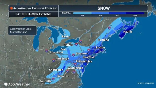
Usually when we are within 48 hours of a developing storm, the forecasters know what we can expect. The storm that’s going to impact the east coast tonight into tomorrow has been difficult. Computer models this past week were predicting anything from less than an inch of snow to more than a foot. It looks now like this will be a classic Nor’easter and have little impact on us here in the Shenandoah Valley. A Winter Storm Watch is in affect for the higher elevations of West Virginia where snowfall may accumulate over a foot. For us, we might see a couple inches, although the snow will most likely melt when it hits the ground.
The WSVA exclusive AccuWeather forecast for Harrisonburg and the Shenandoah Valley
Today: intervals of clouds and sun. High 59. Winds west-northwest 6-12 mph.
Tonight: increasing clouds with a mix of rain and snow late. Little to no accumulation. Low 33. Winds northeast 3-6 mph.
Sunday: much colder with periods of snow. accumulating 1-2 inches. High 38.
Winds north 7-14 mph.
Sunday night: a little snow early. Total snowfall 1-2 inches. Low 29.
Monday: mostly cloudy, windy and cold. High 34. Winds north-northwest 12-25 mph.
Monday night: partly cloudy and breezy. Low 18. Winds northwest 10-15 mph.
Tuesday: cold with times of clouds and sun. High 38. Winds west-northwest 4-8 mph.
Wednesday: cloudy skies. High 50. Winds south-southwest 5-10 mph.
Sunset today will be 6:00 p.m.
Sunrise Sunday will be at 6:57 a.m.
Historical weather data for this date at the Dale Enterprise Weather Station
High 73 in 1930
Low: -1 in 2025
Precipitation: 1.31 in 1954
Snowfall: 14.0 in 2015