

HARRISONBURG VA: (ROCKTOWN NOW) – Will the Shenandoah Valley be impacted by Tropical Storm Erin, now strengthening in the Atlantic Ocean? While the current projected path would bring the storm toward the east coast, the National Hurricane Center says it’s still to early to tell. Here’s what we do know.
Tropical Storm Erin forms, to become first Atlantic hurricane of 2025
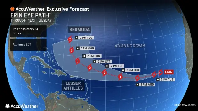
Tropical Storm Erin is steadily intensifying in the eastern Atlantic Ocean. The storm is currently located about 690 miles west of the Cabo Verde Islands and is moving westward at a brisk pace of 22 mph. Erin has sustained winds of 45 mph and a central pressure of 1004 mb, indicating a strengthening system.
Meteorologists expect Erin to continue gaining strength over the next few days due to favorable environmental conditions, including warm ocean waters and low wind shear. Forecast models suggest that Erin could become a hurricane within 48 hours and potentially reach major hurricane status—Category 3 or higher—by August 17, with winds possibly exceeding 115 mph.
Although no land areas are currently under threat, forecasters are closely monitoring the storm’s path. A west-northwest turn is expected later this week, and depending on how the Bermuda High and other atmospheric features evolve, Erin could pose a risk to regions such as the Caribbean, Bermuda, or the southeastern United States.
The storm has already had deadly consequences in Cape Verde, where severe flooding prior to its classification as a tropical storm led to six reported fatalities. While no watches or warnings are in effect at this time, coastal areas along the U.S. East Coast may experience rough surf and dangerous rip currents later this week as Erin progresses.